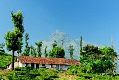
For variety and beauty of scenery, there’s little to beat Wayanad, astonishingly lush even by Kerala standards. The storied peak of Chembra looms out of the mist to stand watch over this pleasantly cool and wonderfully virgin slice of green (Wayanad means “land of paddy fields”). Best of all, this part of Kerala remains pretty much off the tourist track.
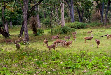
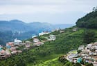
Plantations of coffee, tea, spice (pepper, cardamom), vanilla and rubber alternate with rice paddies, burbling waterfalls and reserved forests of shola and teak jungles. The shola forests are home to giant squirrels and leaping frogs (among other wildlife), but Wayanad is a treat for elephant lovers. Wild elephants are rarely out of sight in the Muthanga (towards the southeast) and Tholpetty (north) game parks, which make up the Wayanad Wildlife Sanctuary, part of the incredibly biodiversity-rich Nilgiris Biosphere that straddles Kerala, Karnataka and Tamil Nadu.
Wayanad offers stunning trekking trails for the adventure traveller. It’s best to put up at one of the homestays around here (Kerala was the first state to offer homestays for tourists), most of them located on plantation estates. To discover the south of Wayanad, make Kalpetta, the district headquarters, your base; for the north, Mananthavady is the ideal base.
History
The pictorial engravings inside the Edakkal Caves, and the big boulders in the forests of Pakshipathalam, speak of a past that goes back into the mists of prehistory. In fact, archaeological finds point to human habitation in the forests of Wayanad stretching back as long as 3000 years.
With the arrival of the British came the plantations, the region’s lushness proving to be ideally fertile ground for the planting of tea and other cash crops, leading to prosperity in the region. Wayanad became a district in 1980.
Geography
Gorgeously – and ruggedly – nestled in the midst of the seven mountains that surround it, verdant Wayanad, in the Western Ghats, features landscapes ranging from semi-tropical grasslands to steep, mist-covered ridges in the uplands. The highest point here is 6890ft (2100m), and the lowest 2461ft (750m). The River Kabini, a tributary of the Kaveri, is the main river flowing through Wayanad.
Weather
A large part of Wayanad lies in the middle and upper reaches, away from the coastal swelter of much of Kerala. The summer heat (it can reach 36C at lower altitudes) is tempered by the breezes coming off the mountains and from the forests. The green surrounds of Wayanad come alive during the rains, though adventure travellers are advised to give the region a miss during these months.
How to reach
Wayanad district is 70km from the coastal city of Kozhikode – the Mysore-Kozhikode highway (NH-17) slices through the region.
Kalpetta is connected by bus to Bangalore and Mysore, and also to Kozhikode (2hrs) and Mananthavady, for the Tholpetty sanctuary (27km, 1hr).
The nearest airport and railhead are in Kozhikode.


 Share Via