Located out in the Atlantic, the isolated Azores is 1564km directly west of Lisbon, Portugal, and 3900km off the North American coast. This chain of nine islands, all volcanic in origin, was colonized by the Portuguese in the mid-15th century. The islands’ location, almost bang in the middle of the Atlantic Ocean, has proved of great strategic value. Today, they are a key mid-ocean refueling and pit stop for commercial airlines, international shipping, cruise ships and private yachts.
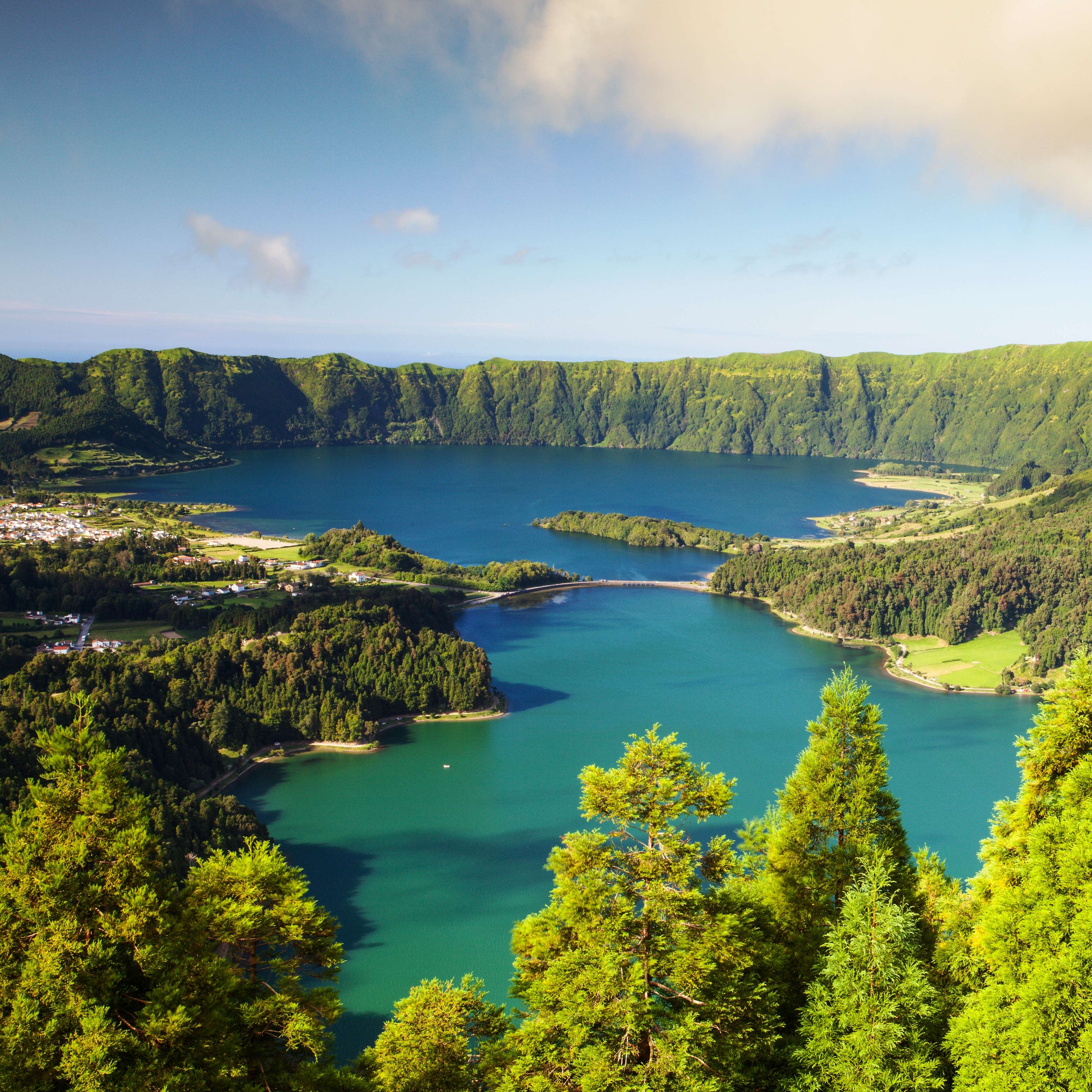
Extremely popular for deep-sea fishing, wine production, many varieties of tropical fruit and local cheeses, the Azores is increasingly becoming a favorite tourist destination. Even the nonchalant traveller will be smitten by the emerald-green and sapphire-blue lakes, volcanic craters and cones, verdant grasslands, 15th-century churches and majestic manor houses.
There are many stories, of fishermen and shepherds, describing the archipelago’s beauty. But one tale, told by a holidaymaker, stands out. As a foreign couple was silently admiring the Caldeira das Sete Cidades, twin lakes in the heart of a volcanic basin, they were interrupted by their six-year-old son, who asked: “Is this God’s home?”
The islands, and their Exclusive Economic Zone, form the Autonomous Region of the Azores, one of Portugal’s two autonomous regions. Its main industries are agriculture, dairy farming (primarily cheese and butter products), livestock ranching, fishing and tourism – the latter is on its way to becoming the major service activity in the region. In addition, the Azores government employs a large percentage of the population directly or indirectly in the service (tertiary) sector.
History
The Azores was granted status of an “autonomous region” in 1976. Through an amendment to the constitution of the Republic of Portugal, a system of self-government was established.
There have been many stories and myths associated with the Azores. Various Genoese and Catalan maps have been produced since 1351. Some chroniclers note that sailors were aware of the islands and visited them while on their way back from the Canary Islands, during the reign of Portugal’s King Afonso IV (c. 1340-1345). In Thomas Ashe’s “A History of the Azores” (1813), the author identified a Fleming, Joshua Vander Berg of Bruges, who made landfall in the archipelago during a storm on his return to Lisbon; Ashe claimed that the Portuguese reconnoitered this area and later claimed it for Portugal.
According to the records, the first islands were “discovered” in 1431 by Gonçalo Velho Cabral, a captain in the service of Infante D. Henrique (better known as “Henry the Navigator”), though explorer Diogo de Silves (1427) also gets credited for the same.
It is commonly known that the islands received their name for the goshawk, “Acor” in Portuguese, as it was a common bird at the time of discovery. But there’s little proof that the bird nested or hunted in the islands.
Geography
Due to the geographical dispersion of the islands, the Azores – the western border of the European Economic Community – encompass an Exclusive Economic Zone of close to 940,000sq km.
Because of their location, the islands are divided into three groups based on their relative proximity: the Eastern Group (Santa Maria and São Miguel), the Central Group (Terceira, Graciosa, São Jorge, Pico and Faial) and the Western Group (Flores and Corvo). The minimum distance between two islands is six kilometres (Pico and Faial) while the maximum distance, dividing Santa Maria and Corvo, is approximately 600km.
The archipelago is located in the middle of the northern part of the Atlantic Ocean and extends along a west-northwest to east-southeast axis. The islands formed over the millennia due to frequent, and often intense, volcanic and seismic activity. Earthquakes have been common in the region – the most severe was recorded in 1757, near Calheta on the island of São Jorge. This quake exceeded seven on the Richter scale.
Weather
The islands benefit from the Gulf Stream, and thus enjoy a mild temperate climate throughout the year. The average temperature varies between 11C and 26C, depending on the time of year, while the seas surrounding the Azores average between 15C and 25C. Being so far out in the Atlantic, the islands are prone to rainy days at any time of the year – without these showers, of course, you would not enjoy the beautiful flora! Between June and August, you can expect lovely days, warm and sunny, with average temperatures between 15C and 26C (sometimes, as high as 30C). It can, however, be quite humid during these months, especially on the coast or in areas where there is a lot of vegetation.
Flora and Fauna
The vegetation on these islands has changed appreciably over the years. Close to 95 percent of laurisilva – laurel forest usually found in subtropical regions – has been wiped out for its prized wood, and also to clear land for agricultural purposes. Consequently, more than half (approx.) of the insect species on the Azores have either vanished or are in danger of extinction. Also, due to increased emigration, many cultivated lands now lie abandoned, and invasive plant species have proliferated in these places.
The Azores is home to two endemic bird species. The endangered Azores Bullfinch, or Priolo, is found only in the laurisilva forest, in the mountains towards the east of São Miguel. Meanwhile, there have been only two recordings of breeding grounds of the Monteiro’s storm petrel, a seabird – though it has been acknowledged that this species is more widely distributed. The islands are also home to the Azores Noctule, a bat that feeds, unusually, during the day.
The Formigas atolls, including the area known as the Dollabarat Reef, boast an environment rich in aquatic species, among them black coral, sharks, manta rays and sea turtles.
How to reach
Flight connections from the UK are excellent and there are lots of options that can be considered from Gatwick, Manchester and Heathrow airports. Local airlines fly daily from Lisbon to the islands of São Miguel, Faial and Terceira.
There are also flights from Amsterdam, Stockholm, Barcelona, Copenhagen, Dublin, Frankfurt, Madrid, Munich, Paris, Oslo and Zurich (Europe), and from Bermuda, Boston, Chicago, Fort Lauderdale, Miami, New York, San Francisco, Montreal and Toronto (North America and the Caribbean).
Getting Around
Air
All nine islands are linked by the local airline (SATA Air Azores), whose planes operate scheduled flights around the archipelago. They operate more like buses, making pit-stops on each island for a few minutes and then flying on to the next one. Planes usually have a capacity of between 40 and 80 passengers. With international airports, the islands of Santa Maria, São Miguel (Ponta Delgada airport) and Terceira (Angra do Heroismo airport) are well connected, though there are flights to the other islands (operated by the regional airline, TAP Air Portugal).
Ferries
These are fairly limited but it is possible to sail between Flores and Corvo, and between São Miguel and Santa Maria. There is a good service around the central group of islands, particularly between Faial, Pico and São Jorge.
Car hire
Available on most islands – vehicles are generally new and range from super-mini to people carrier. Azorean roads, although sometimes bumpy, are generally traffic free and fairly well signposted on main routes (the Portuguese drive on the right). Mopeds and bicycles are also available for hire; a European-style license, with photo ID (or an old-style license and passport), is required for all motorized vehicle hire.
Taxis
These are an excellent option for getting around as many drivers speak English (and prices are low). The vehicles are generally quite new and of a high standard.
Bus
Buses run on all of the islands and are a very inexpensive (though slow!) way to get around. The best service is offered on São Miguel, where the main towns are linked three or four times a day. However, the service is definitely designed for locals rather than visitors, so if you want to see all the sights, you might be better off hiring a car.


 Share Via


