Situated in the Indian state of Meghalaya, Cherrapunji is a sub-divisional town in the East Khasi Hills district. Regarded as one of the wettest places on the planet, the town observes rainfall round the year. It has now been renamed to Sohra by the state government. Often regarded as a paradise for nature lovers, the town has a number of spots that drive the economy of Meghalaya by attracting tourists and foreign exchange.
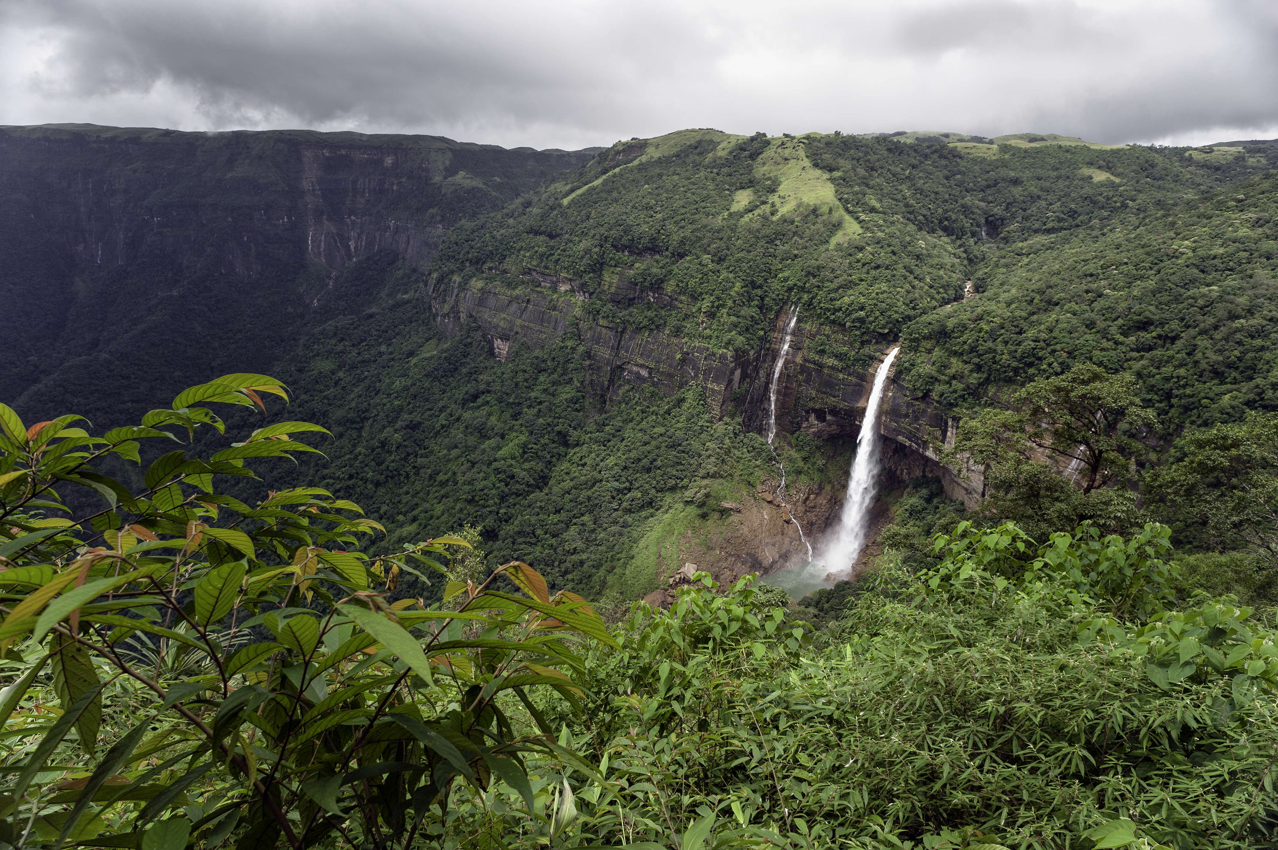
One such point here is Mawkdok Dympep Valley View, which commands captivating views of the valley below. Nohkalikai Falls, Dain Thlen Falls and Seven Sister Falls look even better in the rainy season, when the volume of water in the rivers increases. The area around Cherrapunji also has other natural marvels like Mawsmai Caves, and Ka Khoh Ramhah, also known as Pillar Rock. Structures like the Monument of David Scott, British Cemetery, Thomas Jones School of Mission & Evangelism, and Nongsawlia Presbyterian Church showcase the British legacy of the town. The noted Thangkharang Park and Eco Park are home to many orchids that are endemic to the area.
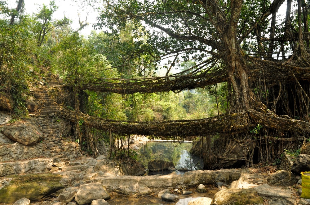
Living Root Bridge, Double-Decker Root Bridge and Umkar Root Bridge are a testament to the naturalistic skills of the Khasi people, who live here. They place trunks of betel trees across streams, joining the stems of fig trees growing on both sides. With time, the hanging roots of the fig tree entwine around the betel tree trunks like creepers. The bridges are further strengthened and stabilised with sticks and rocks. Trekking to the living root bridges is very popular around here. Canyoning, wherein one has to cross rivers and climb steep boulders, is a popular activity around the town due to the abundance of rivers and hills.
The tribal people here produce a unique kind of honey, flavoured with oranges. Apart from this, jewellery and traditional handicraft items, mostly made out of cane and bamboo, also give an insight into their culture. The Khasi people live in a matrilineal society, wherein the women take care of the household and inherit the property.
Valentina Pakyntein, working as an anthropologist at Shillong University, believes that the tradition is centuries old. According to her, the Khasi women practised polygamy in earlier times, and as a result found it hard to determine who the father of their children was. An alternative theory links the tradition to the warring culture of the community. It suggests that as the men were busy fighting with other communities, it was the women’s responsibility to run the household chores.
Pork and other red meats are major ingredients of Khasi specialities. Sohra Pulao is the signature dish of the region that is cooked with vegetables and oil, but no spices. North Indian and Assamese influences in the flavours of Cherrapunji are quite evident.
History
The actual name of the town is Sohrapunji. The term Punji means the head village, where the seat of power of the chieftain lies. The British used to pronounce the town’s name, Churra. Hence, the combination of the two evolved to its present name, Cherrapunji. The word Cherrapunji means the land of oranges. Since the town is famous for orange groves and orange honey, this name was given to it by tourists. Despite heavy rainfall throughout the year, Cherrapunji faces severe water shortage, and locals are thus forced to walk or trek for long distances to get potable water. Because of the human intrusion into the forests, the excessive rain has washed away the topsoil in the region that drastically affected irrigation and eventually, agriculture.
The Khasi people or Khasis are the dominant indigenous tribe living in the town, with a history dating back to the early 16th century. They were ruled by Syiems (chiefs) of Khyriem between the 16th and 18th centuries. In the year 1883, the British took over the control of the Khasi Hills, when Tirot Sing was the local chief. David Scott was the administrator of Northeast India from 1802 to 1831.
Geography
Cherrapunji lies on a plateau, which rises to around 6000 metres above its encircling valleys, in the southern part of the Khasi Hills. Located about 1484 metres above mean sea level; the town is around 156 KM from Shillong, the capital of Meghalaya. Because of winter droughts, the vegetation in the region is chiefly xerophytic, notwithstanding the fact that the town is one of the moistest places on earth. The surrounding valleys are covered with dense and diverse vegetation. A few endemic species of wild plants also thrive here.
The terrain in and around the town is wavy with clusters of shrubs scattered everywhere. The slopes above the valleys are densely packed with tropical rainforests. As the topsoil here is mainly rocky, it does not encourage vegetation growth. However, it has been predicted by geologists that the tableland of the town was a thick forest long ago.
Weather
Cherrapunji features a subtropical highland climate with dry winters. The town receives heavy rainfall round the year with an annual average of 11777 mm. The mean annual temperature in the region is 17.3 degree Celsius, with an average of 11.5 degree Celsius in January, and 20.6 degree Celsius in August. Although, Meghalaya has four main seasons, namely spring, monsoon, autumn and winter, monsoon (May to September) is the one, which predominantly exists in Cherrapunji.
The town observes both the southwest and northeast monsoonal winds that contribute to its single monsoon season. In fact, it holds the record for the maximum rainfall in a calendar month as well as year. It received 26461 mm of rain between 1st August, 1860 and 31st July, 1861, and 9300 mm in July 1861. The atmospheric humidity in the region is high during the monsoon months, with the average annual relative humidity of 81 per cent.
How to reach
The city closest to Cherrapunji is Guwahati in Assam that is connected to the rest of India by air, roads and rail. The city is around 150 KM away and reachable in 4 hours’ drive from the town.
Guwahati International Airport is the primary airport that serves as the entry point to Northeast India. The closest to Cherrapunji is Umroi Airport, which is about 30 KM from Shillong.
The nearest railway station to Shillong as well as Cherrapunji is in Guwahati that has regular express and passenger trains from and to major cities.
Getting Around
Shared black and yellow taxis can be hired to travel across the town. Moreover, for a personalised experience, a private taxi can be taken.


 Share Via


_1438583237_7QhekM.jpg)
_1438583442_6DIFhO.jpg)
_1438583397_DZoIUc.jpg)


